


by David Wicks, 2013
Roughly alphabetical. An attempt to record some stories before I forget them.
I hope the children of Cromhall especially will find all this interesting and that it encourages some exploring and questions!
One of the two manors of Cromhall. The separation dates from Saxon times when, according to the Domesday book, Cromhall was held by the King (Edward the Confessor), administered by two brothers. After the conquest they were given into the care of Roger de Berkeley.
This manor was presented in 1148 to St.Augustine's Abbey in Bristol by Robert Fitzharding, Robert Lord Berkeley, of Berkeley Castle, who had been granted the Hundred of Berkeley by King Henry II, after the original de Berkeley family (of Dursley) had been dispossessed for supporting King Stephen. The other manor is called Cromhall Lygon after the Lygon family who were Lords of The Manor in the middle ages. There were other families before them, the De Cromhales, for example, who were mentioned in many Berkeley Castle records. The De Wantons were also Lords of the Manor before the Lygons and after them the Throckmortons. The Ducie Family became Lords of the Manors in the seventeenth century.
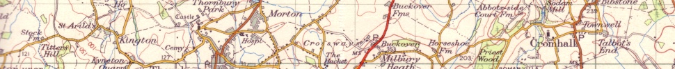
Although there are stories about abbey buildings or a monastery at Abbotside it was only a farm or 'grange' of the abbey, as was the St. Augustine's Farm at Arlingham. The Abbey Farm Courthouse was originally across the valley from Cromhall Court Farm where the farm buildings and yard exist today at Bishopsgate. The barn buildings are possibly from the old manor farmyard. The abbey steward lived at the court house. The old well on the hillside probably dates from this period. The Webb family were owners of Abbotside Court Farm for much of the eighteenth century. The stone balls and gates at the front of Court Farm were originally on the front gates of Abbotside Court Farm. There were old gable ends beside Abbotside Lane until the 1980s when they were demolished. Since they were plastered and whitewashed inside they were most likely to have been the ends of cottages shown on the 1760 estate map of Abbotside. There are at least ten houses shown on the Estate map and tithe map (1838) on the hillside. Some old plough ridges become visible on the hillside below Abbotside Farm House in snowy or frosty weather, as well as old field and cottage garden boundaries. A boundary ridge in the corner of the field overlooking Sodam Mill is possibly much older, even prehistoric.
Another old story told of a tunnel to the church from the 'monastery' in which the 'monks' used to hide from Henry VIII's men with gold from the monastery. There were cellars under some of the foundations on the hillside which have probably been filled in now but were there in the 1920s. Another story told of fish being transported to Bristol in barrels by the monks. The story was told about the fish ponds in the Conegres. There may be something in this but the workers on the farm were probably laymen or lay brothers supervised by a Steward, the fish ponds were in the wrong manor so it makes the story improbable.
The manor was handed over to Bristol cathedral and the Bishop of Bristol after the Reformation which explains the name Bishopsgate. Priestwood also dates from this connection.
A Latin record book, The Compotus Book of St. Augustine's Abbey (in Gloucester and Bristol Records) records a dispute over a pond in Cromhall, possibly the mill pond, which, since the stream was, and still is the boundary between the two manors; could easily be a cause of disagreement. There is also mention of limestone quarries and lime-kilns for quicklime used for whitewash,plaster, mortar and soil improvement. These quarries are still just visible where the lane along the edge of Priestwood heads off to Milbury Heath. Further along the lane to Milbury Heath behind the gate to Abbotside Farm were more limestone quarries. Cromhall lime was especially highly regarded. It was produced into the 1930s on either side of the road to Leyhill. Cromhall Abbots has the right to appoint a churchwarden and births, deaths and marriages in the Parish records, census returns and tax records distinguished between the two manors. In the Middle Ages manor courts were held at both Court farms and records of fines exist, for moving hurdles in the common fields, so that a plot received an unfair share of manure from the sheep in the fallow field. The fletcher in Fiddler's Bottom was fined for not keeping his thatch in good repair. Other fines could be for 'encroachments' on the common land, taking timber from the Lord's wood or moving marker stones in the 'Great fields'.
The military muster rolls ( Men and Armour for Gloucestershire in 1608, by John Smith, Alan Sutton Publishing) show that the male inhabitants of Cromhall Abbots were largely involved in textile working and other crafts as well as husbandry. The 1851 census of Cromhall has many occupations listed, quarrymen, masons, lime-burners and coal miners as well as weavers, blacksmiths and shoemakers.
There is a plausible legend that a hermit (Anchorite) lived on the hillside in Cromhall Park, (now Tortworth Park).This cell was still visible in the 18th. Century according to several accounts, it is possible it was on Abottside Hill but most accounts suggest it was on the Leyhill side. The story, well documented, is that when St. Augustine was sent to encourage the Celtic Church in Britain to come under the control of Rome and use the same dates for Christmas and Easter he met with a delegation of clergy (‘monks’ usually but probably Bishops) from Bangor who went to see a venerable hermit in this place, before meeting Augustine at an ancient oak tree at Aust. The hermit’s advice was to watch how Augustine behaved. If he was humble and rose to meet them they should trust him. He didn’t rise to meet them and they still allowed the Roman Church to set the rules, resulting in the Celtic Church losing its identity. There is no record of what the Hermit thought about this. There is no evidence of the anchorite’s cell now, as far as I know. It was probably on the top of the hill, also known as ‘Lover’s Leap’, beside Harris’s Wood.
>> Find out more about the Cromhall Hermit.
Is named after a story that a Roman soldier threw himself off the top, ‘into the lake’ after being refused by his ‘British maiden'. I think this is an Edwardian romance and since the lake wasn’t there until the nineteenth century there isn’t much to commend it as a true story, still, its why a place is called what it is, or was. I don’t know if anyone uses it now. This is the poem telling the story of Lover’s Leap. It looks like someone at the school in Cromhall or Tortworth may have written it, possibly around 1900 judging by the language and style. Hilda Kimber and Edith Kimber knew it and it would not surprise me if they knew who wrote it but they wouldn’t let on! It is very long and by the end you feel like jumping off Lover’s Leap too!
The Lover’s Leap, A Gloucestershire Legend
The Roman Camp on Tortworth Hill / Stood high o’er Severn’s sedgy plain, / Proclaiming far the Conquer’s will, / To Britons in their own domains. / Aloft, Imperial Eagles bright / Flashed proudly in the summer’s sun / And gleaming in the ruddy light / Boasted of fiery battles won. / Upon the Southern slopes, there lay / A vineyard’s terraces and walls / Strange contrast these to wars / The acts of peace ‘mid trumpet calls. / Along the ridge a pathway led / Down to a narrow dell below / Where bubbling from their rocky bed / The sparkling waters gush and flow. / Forth from the camp a warrior strode / Leading a band of stalwart men / To clamber down the slippery road / Towards the spring in Cromhall glen. / Advancing fast, the leader spied / A maiden kneeling o’er the spring / “ A prize - a prize! ” the soldier’s cried / Their shouts along the valley ring. / The maiden startled by the sound / Sprang to her feet in breathless fear / And to a knoll with sudden bound / She leaped to scan the danger near. / At last she stood and with a frown / At once defiant and abashed / She eyed the foeman striding down / Who roughly through the bracken crashed. / The warrior holding back his band / Advanced to meet her where she stood / With courteous bow and helm in hand / He smiled away her frightened mood. / “Fear not, I pray” he gently said / “ No danger threatens thee I ween. / We search for water, my fair maid / ‘Tis sweeter now where though hast been!” / Then lifting up her earthen vase / He placed it lightly on her head / And led her through the straightened path / To Cromhall, whence the maid had sped. / Oft from the Camp did Julius stray / Ere Pheobus yet his course had run / And straight to Cromhall make his way / to press the suit he had begun. / The British maid he fondly loved, / Who, taught to hate his cursed race / Unfailing ecstasy had proved / To one whose both form and grace / Had won her pure and trusting soul / Until she worshipped as a god / Her lover, who her kisses stole / As o’er the moonlight path they trod. / The dream-like courtship proved too brief / Swift was the Wrath of Olivia’s sire, / The camp had been his life-long grief / And Bloody Acre roused his ire. / A British chief from Severn’s bank / Had sued for lovely Olivia’s hand / Silurian neighbours vouched his rank / His flocks and herds and fertile land. / The sire in haste approved his suit, / Nor stopped to ask the maid’s consent, / But bore her off beyond pursuit / And straight to Severn’s pastures went. / With sighs and tears the maid was wed / In vain she prayed, in vain she cried, / In vain from room to room she fled / The sullen bridegroom d-d his bride. (what is that word ?! ) / The lover maddened by her fate / Stalked wildly over hill and dale / And vengeance swore and deadly hate / Fierce were his threats and loud his wail. / One eventide he scaled the height / Of a tall rock that towered above / The teaming camp still bathed in light / The well known spring that murmured love. / The world was darkening o’er his youth / The camp was dull, his comrades rude / Old Roman faiths were void of truth / Philosophy was false and crude. / In mournful gloom he viewed the scene / Cast down were all his hopes in life / No soldier’s dream as there had been / No glory now in arms or strife. / His fainting spirit craved for death / So brooding o’er his mortal woe / He drew a long and struggling breath / And plunged into the depths below.
Phew!
The large field after the bungalows on Church Lane on the way to the school. I have not been able to find the meaning of the name but it could be from a personal name or a description of its character as a field, as in ‘Starvall’ near Hawkesbury.
(I am not sure if this is a rustic joke!) Is the name of the narrow lane between Church Lane and Spring Lane.
The next field is called Buttcroft. A plot (croft) often for a cottage back garden and paddock with hedges or hedge-banks (butts) which was sometimes a good place to practise archery without losing your arrows or hitting people or animals.We don't know if it was ever used for that.That assumption is made at Wickwar, (Buthay), for the same reasons.The popular place for archery practice was more often the churchyard.
Probably this is this is a personal placename as in ‘Bibba's Tun’, or farmstead. Sometimes farms were enclosed by a stockade or bank and it may be that some of the field marks on Bibstone hill are from the early Anglo-Saxon settlement. The remaining old oak tree may be over three hundred years old judging by growth ring counts on similar oaks. The old barn which existed until recently in the field behind the Royal Oak suggested that there was a farmyard here. The old well in the Oak courtyard suggests an early date for the site probably much earlier than the existing buildings.
The field on the top of Bibstone Hill is called 'The Hayes' which means 'The Hedges' and suggests it was an early enclosure.
This sounds like a personal name but I haven't found out when it was first used. The name of the hill on Ordinance Survey maps is Wick's Hill. This suggests the hill was named after a Wicks or Wick. The earliest name recorded for it is ‘Wykesheath’. This could mean the Hill of the Heath of the Wicks (dairy farms) or more interestingly of the ‘vicus’. A vicus is a settlement outside a Roman fort. Just behind the hill is 'BloodyAcre Camp' originally an Iron Age hill fort which may have been reused by the Romans, as many local sites were, either as temporary bases or temple sites. There are confusing accounts of a Roman 'pavement' being found there by an Earl of Ducie who was interested in Antiquities. Unfortunately this will have been before archaeology became the science it is today so records are confusing and the mosaic is lost. It may have been from the Roman Villa site at Abbotside, and it may still exist in a box in Stroud Museum.
Coincidentally Wickses did live on the hill, at the quarry called Hawker's Knapp and at the base of the hill, where a small barn still survives. The farmer there, Thomas Wicks, was nicknamed 'Growler' Wicks. This was clearly a family feature although my father's bass voice was more harmonious than a growl!
This hill fort is a good example of a fortified site using the hillside as part of the defence and having two rows of banks and ditches (multivalate) with a remaining gateway on the outer face.
It is covered with well-established trees inside the Tortworth Estate Park wall next to Gambrill Lane, beside 'Scotland' (which may be a reference to a land tax rather than the country). It is possible that the name dates from a story told about a punishment raid made by the village men of the locality against a troop of soldiers who had camped there in the Civil War. The story tells that they had made themselves very unpopular in the village and locality, pillaging and worse, and suffered the consequences. There are no records of this but I suppose that is not so surprising. Which side the soldiers were on probably depends upon who tells the story!
The wood next to Littlewood and Hunt’s Wood on the Charfield edge of the parish. This means ‘Burnt Wood’.
A now filled-in pond at the back of Old Engine House garden, along the edge of the field where the footpath crosses the corner of the field. It was probably a clay-pit used to make bricks perhaps to line the nearby coal-pit shafts. Bricks would have been fired in "clamps" which are freestanding stacks of bricks with layers of coal between them, which were fired in the open. It was a wide deep pool with very yellow clay, rushes and moorhens.
This is a reference to rabbit warrens. Rabbits were introduced by the Normans and were protected from predators and poachers by building them earth banks to burrow in and enclosing the fields where they were kept as well as providing gamekeeper watchmen. In Cromhall both the Bishop and the Lord of the Manor of Cromhall Lygon were given the right of ‘Free Warren’ which meant they could hunt on their land and keep rabbits. The Coneygres are the fields to the right hand side on Spring Lane on the way to Fiddler’s Bottom. There are no visible earth banks, they could have been incorporated into the hedgerows or dug up when no longer needed. Interestingly at least one family in Fiddlers Bottom were glove makers. Felt was made from the rabbit fur and used to make gloves and hats. The fish ponds in the Coneygres, which are usually dry and overgrown these days are the remains of the stew ponds most manors had, to provide fish for Fridays and fast days. The remains of the old water control sluice out of the fishponds are still visible but badly eroded by modern activities.The stream had been dry for years until summer 2012.
Two of the fields next to Court Farm are called Upper and Lower Park and would have contained deer to provide sport and feed the Court’s household. The old Court was in the paddock at the side of the churchyard beyond the present Court Farm barns. The wood along the course of the stream from Quartzite quarry to Court Farm is called Dyer’s Brake after the Dyer family who were owners of Court Farm, after the Hicks family, in Cromhall. From a Mr. John Dyer Lord Ducie purchased the property in 1876.
This name probably resulted from the Tortworth Estate’s fine cottages, Allotment Row, built in 1858 on the old allotments site. They are very good examples of architect designed estate buildings as are the farmhouses, barns, Village Hall and buildings associated with it, originally a hospital (Infirmary) and reading and meeting rooms. The 1857 plans and architects drawings for cottages for Lord Ducie by Fosters and Wood of Bristol exist in Gloucester records.
This means ‘cowshed’ or cow ‘shippen’ lane. The cow shed was probably where Cowship farm is now, in Wickwar parish. Often called ‘Wickwar Lane'.
This is an old name but I don’t know who Cole was. There is a Hester Cole in the burial record in 1793. I will update this if I find out.
This is a field south of the Wotton Road at the end of the village which may relate to the old myth that if you could capture a cuckoo and keep it, summer would not end. I doubt if anyone every believed that but it was a poetic image.
About to celebrate its two hundred year anniversary in 2013 having been founded in 1813 by Christopher Keeling, the mine owner from No.1, the Green, Heathend and Samuel Long, textile mill owner from Charfield. The original provision was for seven cottages adjoining the chapel to provide support with rents. Christopher Keeling is buried in the graveyard there. There are some interesting graves in the Chapel graveyard. I am finding out about whose they are. One particularly interesting monument is to Jacob Rogers, aged 87, Chelsea Pensioner, deaf according to the 1851census, who served in the Napoleonic wars and was awarded the Egypt medal, but probably lived in India for much of his life. The story is that the chapel was a weaving shed originally but there is no evidence for this.
The history of the Church is well recorded on the St. Andrew’s Church website so I won’t repeat it. The only detail I would add is that the figure of the knight with crossed legs, thought to be a Lygon crusader would be the wrong date for a Lygon as the crusades had ended by the reign of Henry VI (died 1461) when the Lygons took over the lordship. It is more likely to have been a ‘de Cromhall’ as, if it was a crusader, the most likely crusade would have been that which Sir William of Berkeley had vowed to go on in 1271, to join a Holy military order (Templars or Hospitallers) and not return to England. He managed to avoid this banishment when, in 1272, he died. His nephew Maurice absolved the family after his uncle’s death by persuading and paying £100 to Sir John Veel of Charfield, to go in his place. I can’t find any evidence that he went or that any Berkeley and their retinue ever went on crusade despite the Maltese (Pattee) crosses on their Arms, so the whole story is in doubt. The Berkeleys fought in many of the wars in Scotland, Wales and France and so their Cromhall knights and retainers would have too. ‘Sir Richard De Cromhale‘ was ‘slaine’ in Scotland in the reign of Henry III. The prospect that archers from Cromhall as well as billmen and men at arms could have fought at Bannockburn, Agincourt, Crecy and Poitiers is interesting.The manors in the Berkeley Hundred would have had to contribute to the ransoms when a Berkeley was captured at Bannockburn and another at Poitiers. An early knight effigy with crossed legs would have been eleventh or twelfth century at the latest, so not a Lygon. The statue was broken up and built into the church wall anyway so it is all academic. It might re-emerge one day.
The road to Wickwar after Hammerley Down, where Cromhall Quarry lies. Downs are low gentle hills.
This was the name used for the track across Old House Leaze between Bristol Road and Rectory Lane which served as a ‘drive’ for the Rectory, now the "Old Rectory". Old House leaze may have some secrets because none of the buildings nearby would have produced this name and there was a Clergy house on the rectory site before the present Old Rectory building. The stile on Bristol Road from "The Drive" has interesting curved stones providing the sides. These look like they might be made from a sandstone so possibly from Quartzite Quarry? The bill for rebuilding the wall is in Rev. Copleston's minutes in the Church records.
The field just after the houses near the Garage and before Well Cottage. This could be a personal name but may also be a jokey name as an ‘emmet’ is an ant in old Gloster dialect.
This could be just what it says, the ‘far leigh’ at the end of a lane. One of the fields here is called ‘Farleigh’. A ‘farleigh’ is also a sort of death-duty tax where a field can be used to pay instead of money. When ‘Varley’ Farm was named they obviously liked the way it was called in dialect. One day no-one will remember how the older folk spoke if we didn’t have these reminders.
Right, now before we are accused of being rude, a ‘Bottom’ is a small valley in Gloucestershire, as in Waterley Bottom near Wotton-Under-Edge. ‘The Fiddlers’ I was told was the name of a cider house in the 'Bottom'. The house in the middle of the three there now. I am not sure if this is quite right because I think a family named Vidler or Fidler, lived there so it could have been just ‘Vidler’s’. When Jenny Humfris land her family lived there they found a lot of early eighteenth century pottery, from Staffordshire and Donyatt in Somerset, and clay pipes in the garden, just outside the door and windows, as if people just threw anything broken into the garden. I can imagine this but am glad our present pubs are more civilized. On the tithe map there is a malthouse marked as well as the one at the Oak.
This is the field which the footpath crosses to the footbridge to connect Jubilee Lane with Rectory Lane. There is a ‘tump’ near the hedge which is a coal-pit spoil heap now grown over with trees. I suspect this is a joke name for a failed coal-mine venture.
At Heathend, as well as providing grazing for the local’s milk cows and goats it would have been a meeting place for traveling hawkers and tinkers and traders in the time when shops were rare in the villages. One of the old pictures of the green from the nineteenth century shows a traveling hawker setting up a stall on the green. On the end of the row was the White Horse Inn which was demolished after being closed for many years, to make room for a new building. The pub signpost remained for several years.
The site of a small quarry on the side of Butcher’s hill. I don’t know who Hawker was but it could be the owner or tenant of one of the cottages here, or possibly the quarry owner.Two cottages existed on this site and the remains of the foundations and gardens were still visible in the nineteen sixties. George Wicks lived here in the eighteenth century, before moving to Talbots End. The narrow field next to it is called ‘the lagger’ which is an Anglo- Saxon name for a narrow strip. Several other fields in Cromhall are called ‘lagger’ or ‘legger.' A large field below the Knapp is called ‘Hawkers’ so it could be that the area has that name. There was a ‘Hawkers Wood’ in Cromhall which may have been here.
The name of part of the lane from Talbots End Lane to the quarry at Churchend, in Charfield parish. There was a lime kiln here and a farm which has long since disappeared. It may mean a clearing ‘Ley’, with hedges, ‘Haws’.
Named after the Knapp quarry. A knapp is a name used for a quarry, probably as a result of the nature of stone-working.
The area between Cromhall village and Bagstone was largely uncultivated or only in patches near Ashworthy farm, Wix Oldbury Farm and Old Close Farm until the enclosures in the eighteenth and nineteenth centuries. Some histories of Gloucestershire suggest it was a dangerous place as robbers and highwaymen hung about there. It didn’t mean it was not owned by anyone and the coal mines and cottages which sprang up here were allowed by the Earl of Ducie because they provided income in the form of rents and were on otherwise waste land. There was a growth of population in the eighteen and nineteenth centuries which needed housing and increased agriculture. Some of the cottagers were mineworkers. One of the owners of the coal mines, Christopher Keeling, lived on the Green at Heathend. The growth of little hamlets of mineworkers and metalworkers can be seen at Coalpit Heath and around Rangeworthy at North Road. The building or improving of the main road to Bristol for the ‘turnpike’ Toll Road meant the Heath became busier and safer. There was a toll house at the junction of Bristol Road and Stidcot Lane at Bagstone (the tariff board is in Bristol museum) and one at the junction of New Road Hill and the road to Bradley Green near Wotton. On the 1839 enclosure map a turnpike gate is marked across the road at the smithy. Although there is no toll-house mentioned, in the 1831 census a James Stafford (aged 69) is listed as a labourer working for the Turnpike Trust, so maybe he was the Gate-keeper. There are three milestones on the old toll road through Cromhall. They originally had the distance between Bristol and Wotton recorded on them but it was the duty of the local home guard to remove this information in case German parachutists didn’t know where they were! There is something written on the stone but it is hard to read. The most northerly is on the straight from Bibstone to Hammerley Down. The next is opposite the old stone stile at ‘The Drive’, by the bus stop and the last is at the end of the strait out of Cromhall, after Hunters Hall, on the Common, just before the brow of the hill, at Kite’snest, as the road curves down to cross Winpenny bridge at Bagstone.
The hillside on the way to Charfield,The site of Cromhall ‘Slickstones’ Quarry. Names with ‘Ley’ suggest early place-names as they mean a ‘clearing’ in a wood or forest. In the middle ages most of the area between Kingswood, Wotton-Under-Edge and Kingswood, Bristol was The Royal Chase, which does not mean it was completely wooded, some ‘hunting forests’ have no woods, but suggests it was quite forested in this area. Remains are at Michaelwood (Great Wood) and Huntingford as well as Lower Woods, Inglestone Common.
Just outside the parish boundary near Baden Hill on the way to Tytherington. There is a good example of an old estate field barn just above the wood.
Originally an access lane for ‘encroachments on the common'. Named after Queen Victoria’s Golden Jubilee in 1887 or her Diamond jubilee in 1897?
The long field on Butcher’s Hill above Knapp Lane.
The crossroads at the meeting of Bristol Road, Church Lane and Talbots End.
There was an elm tree on a little island on the top of the hill until the nineteen fifties when it was cleared to make way for road widening. There may have been a wayside cross here to explain the name but I have not seen any reference to it. The War Memorial was here before being moved to the churchyard. The Red Lion public house, now a private house, is prominent on the photographs taken in the nineteen thirties which exist as postcards.
The continuation of Talbots End Lane along to the fields at ‘Lake’, which means stream in Anglo Saxon, ‘Lacu’ on old documents. The old boundary stone for the boundary between the Berkeley Hundred and the Hundred of Grumbold’s Ash is still to be found on the edge of Lake Copse, also once known as the ‘Withy Bed’ when most of its trees would have been pollarded willows used for hurdles, wattle walls and baskets.
The branch of Lake Lane which heads towards Churchend ‘Wickwar’ Quarry is ‘Foxholes Lane’. It is a good place to see foxes, deer, buzzards and sometimes hares.
Legendary location of a romantic story, overlooking Tortworth Lake.
The wood just over the parish boundary before the road to Wickwar. It is quite big, but I suppose it is all relative. Next to Hammerley Wood near the road is Brand Wood and Hunts Wood. They have boundary ditches and banks which are a sign of ancient managed woodland.
Jubilee House was originally a hunting lodge on the edge of Cromhall Heath. Mushroom Castle was a local name, exactly why it had that name is unknown.
The only remaining public house in Cromhall, having been in earlier times ‘The Falcon’ and ‘The Duke of Marlborough’s Head’.
On the site of an old settlement probably, the date of 1674 in the present building may not be when it was built, but a restoration record on a new fireplace. The old oak trees on Bibstone hill probably encouraged the name.The remaining tree looks like it could be at least three hundred years old. A room under the Oak was used for cart-building. The story goes that after one cart had been built it had to be dismantled to get it out. People have not forgotten! There must have been some leg-pulling after that. The village originally had six pubs at least, Hunter’s Hall at Heathend, The White Horse on the Green, The Red Lion at Longcross, Fiddlers cider house at Fiddlers Bottom, The New Inn at Bibstone and The Royal Oak, there is a suggestion that a cider house existed in Cowship Lane but if there was one I don’t know where it was. Cider was made in the village at Heathend House Farm until the 1980s. In the past all the farms would have produced cider to provide for the workforce. Many orchards survive but most have been rooted up. Old maps show a lot more orchards than exist now. The number of trees may have declined, especially since the Dutch Elm disease but the overall acreage of woodland seems to be much the same as it was in the Tithe survey.
The end of the village near the Park gate into Tortworth Lake. Quiet now but much busier in the past. Most of the park and lake actually lies inside Cromhall Parish, the parish boundary stones are at the far end of the lake. Before the park and lake were constructed, after Sir William Ducie obtained a license to enclose Cromhall Park in 1661, there was probably a lane through the valley to Falfield. There was a mill sited on the stream here and a small bridge under the lake appeared when the lake was drained for repair some years ago. Inside the park on the hillside, along the valley to the left of the gate are the remains of ‘The Vineyard’ which was a vineyard producing grapes in the eighteenth century, built by the Earl of Ducie. I remember that the area near the Park wall from Poor End to Sodam Mill was called Everley. This is the name of a clearing and is probably a field name here.
Poorend may have been a reference to the tiny cottages which existed in the valley here until the nineteen sixties. Several of which were one-up one-down cottages which have left few traces but ten houses were marked here on the eighteenth century estate map of the Ducie estate. The small paddocks on the left and right at the end of the lane before the park gate, and in the wood, are the only remains of these cottages’ gardens as well as the periwinkles which grow on the walls.. The quarry at the top of this lane which has nearly been filled in is the only trace of a large lime industry which existed in Cromhall for many centuries. A lime kiln existed here and another up the hill on the far side of the road to Leyhill.
Next to the parish cattle pound in Jubilee Lane where strays would be ‘impounded’ until a fine had been paid for the inconvenience they may have caused. The Padfield family who lived here built farm wagons and were also coffin makers and undertakers.
The Quarry between Court Farm and Trappels Farm off Rectory Lane, which produced a particularly hard roadstone. Cromhall geology is very complicated indeed if you every see a geological map of the underlying rocks. As well as the general carboniferous ‘mountain’ limestone there are several rare rocks and minerals. ‘Cromhall Sandstone’ is a small deposit but apart from the name is probably important for being the source of some of the old stone tiles in the area. Few of them can be seen now but they did exist on Talbots End house and maybe still do, the sheds behind the Village hall, the old pig-styes at Well Cottage, the barn between Jones’s Wood and Priestwood and many outbuildings around the village. Most of these tiles, and the buildings they were on have gone as requirements have changed but it would be interesting to know where they were quarried, I suspect it was in Quartzite Quarry. The Carboniferous Limestone is too hard to carve easily as it is very brittle and dense. It makes a hard building stone which does not allow much detail unlike Cotswold stone.
Some buildings have large blocks for corners, doorways and windows but most are undressed rubble rendered originally with the same stone burnt in local limekilns. The stone, mortar and rendering could all be obtained in the village, and the tiles on some of the older buildings. The whitewash could also come from Cromhall lime. There were deposits of Celestine, strontium sulphate, at Heathend but much of this was quarried by open cast mining in the sixties. It was quite near the surface and the quarries have been backfilled and restored so forget metal-detecting or archeological surveys around Cowship Lane.
The coal deposits were probably quite extensive but not very economical to mine. It is hard to know how long the underground tunnels were but there are traces of shafts, test tunnels and possibly air vents over much of the Heath.
This is the name of the area around the top of the lane from Abbotside which becomes Gambrill Lane. Whether it is called this after a nineteenth century enthusiasm for things Scottish begun by Queen Victoria or a medieval tax is hard to tell. A Scotlands Wood is named on old documents.
I am not sure where this comes from but the ending, if it was ‘Ham’ originally, is a farm and in the Domesday book two mills are recorded in Cromhall. This must be one of them, the other was probably just inside the park gate in Poorend/Parkend where the stream divides.
The footpath down The Rocks slope from the Conygres fields to Sodam Mill. The rock-face here is evidence of quarrying, probably for building stone for local houses. I don’t know if people still call it this. I hope they do, It can be quite slithery!
The lane from the bottom of Cottage Hill which runs to the Conygres, Fiddler’s Bottom and to Abbotside and Priestwood, after a few yards on the left there is a curved section of wall which is where a pump used to exist. There are remains of a pipe there and a wooden beam used to exist which supported the pump. This was the spring which provided the Townwell’, and which ran into the stream serving the fishponds in the Conygres. The lane may have been called Conygres lane beween the Conegres and the top of Fiddler’s Bottom, as that is how it is referred to in the 1838 Tithe map schedule. ‘There was never a ‘Town’ here, a ‘tun’ just means a farm in Early English which often became a village. It could be that the early village was in this area but without excavation we can’t prove that. Wooden, thatched huts don’t leave any trace as any good timbers were reused. There was a farm across the lane where the lorry depot is now. The name moved over the main road as ‘Townwell House’ was named after this spring and modern Townwell was named for its proximity to this house. This name, ‘Spring Lane’, which seems to be ignored now, is probably one of the oldest features in Cromhall, along with the names ‘Townwell', ‘Bibstone', ‘Sodam’ and Leyhill, all of which are Anglo-Saxon in origin.The lane itself is very old, being an example of a ‘sunken lane’ where the road is lower than the surrounding fields. Old footpaths ran parallel with the lane on both sides originally as the lane must have become very muddy. Digging out the mud and muck for manure created the sunken lane. Another example is the footpath along the edge of the Park behind Sodom Mill, from the bridge over the stream up to Gambrill Lane, which must have once been a busy track possibly carrying traffic from Poorend to markets in Thornbury and stone from the quarries (the Cliff) in the woods.This lane once came out near the gate to Gambrill Lane, (this section was filled in quite recently), and connected with the track over the hill through the yard of present day Abbotside Farm to continue along the top of the hill, along Stanley Wood, to meet Cromhall Lane, heading to Milbury Heath.
The road at Stidcot (‘stilt cottage’) Lane which sounds like it has always been likely to flood in the wintertime. Ashworthy Farm, here, must be a very ancient site as the parish boundary extends around it in a very unlikely way unless the farm was there before the boundary. Ashworthy could mean something like ‘ash stockade', and suggests an early Anglo-Saxon site. It could alternatively be named after an individual, ‘Aescela’, according to A.H.Smith in Placenames of Gloucestershire.
The continuation of Heathend Lane from the Green which has disappeared but traces can be seen if you know where to look. It used to connect with Lake Lane and might have been a track to allow the old field strips to be reached.
A part of the wood in the valley behind Sodam Mill which suggests a sheltered place to grow apple trees. There are crab apple trees on the bank there.
This was originally, until the early twentieth century, called Tadbrooke’s End which is its historic name. Talbots End is a recent name, possibly invented because people didn’t know what the original name meant! If it wasn’t for the record provided by John Smith in his ‘Lives of The Berkeley’s’ in the seventeenth century we would not know either. The original Talbrocke/Talbrooke was the man who was granted an eighty acre freehold by Philip De Cromhall in the reign of Richard I (1189-99) which continued down the years as a separate farm from the manor farms. The site of Talbrocke's/Tadbrook's farm was probably the present Talbot’s End House. The name still exists in documents in the nineteen twenties but now the only record is in ‘Talbrockes’ which is the name my father, Tony Wicks, called the cottage in Talbots End previously ‘Varley Farm Cottage’ and part of it,‘Titter-Wren’s Nest’, so that the name would be preserved. The present ‘Talbrockes’ can probably claim to be the oldest house in the village, being built around 1450 as a ‘longhouse’ with a centre passage dividing the people’s living quarters on one side and the cattle on the other. Several other houses in Talbots End have long histories.
The end of Cromhall near Trappels Farm on the way to Tytherington, near where the sewage treatment works are (where did you think it went?). It means ‘tap well’ and must refer to a spring which ran into a trough here.
The field where the treatment works are was always remembered by villagers as where the Roman Villa had been. The villa site is actually in the field behind. The interesting part of this story is that when the treatment works was planned the Thornbury Archaeology group did a rescue dig and found a farming settlement from the Roman period which probably was related to the Villa. Was this an example of a long folk memory?
The name of part of the village which has moved slightly over the years from Spring Lane, across the main road to Townwell House and then to the housing development built on the field behind the Village Hall now named Townwell. Since it is practically the only part of the village where houses face each other over a road it is the nearest we have to a town in Cromhall, so perhaps it is now in the right place even if the meaning has changed. The name is marked below Spring Lane on the Tithe Map.
There are various ‘tumps’ in Cromhall, being the local name for a man-made hump in the landscape. These are the remains of the coal-mining industry which developed on what was then The Common, or Cromhall Heath. The spoil was not transported far as it would have been time-wasting and uneconomical. There are tracks which could be tramways or ‘dramways’, as in Yate, on the site of the various shafts, near the ‘tumps’ which show where spoil was carried. The most prominent shaft, New Engine Pit, has a large waste heap next to it and there is a small ‘Tump’ beside Old Engine House which we called ‘The Tump’ when I was growing up in Heathend. The way this landscape has changed is a sign of how gradually nature recovers from our treatment. It is hard to imagine the heath that would have been here. The story I was told by David Padfield, who loved an old story, was that the stoker-watchman who was meant to make sure that the engine which pumped water out of the pit never stopped, went to the pub one night. Actually it sounds like he went to the pub every night. Since he had been banned at Hunter’s Hall, nearby, and probably at the other nearby pubs ( Like The White Horse, near Christopher Keeling’s, his boss’s house) he went to the Plough at Bagstone, two miles away. When he got back the fire had gone out, the pump had stopped and allowed the mine to flood. It was never making much money. This was enough to make it uneconomical to continue business and it was forced to close. The story is told in several forms, the pubs differ, the end of the story is usually “ and all the miner’s tools are still down there!”. The seams were thin and flooding was a problem which meant a lot of coal was used to pump it out. The Bristol mines, like the ones on the other side of the Severn, in the Forest, did not suffer from explosive gases. There are at least five ‘tumps’ which are spoil heaps in Heathend. An ‘ounty-tump’ is a mole-hill in old Gloster.
The terraced hillside in the park at Poorend which was a vineyard in the nineteenth century. The stone retaining walls can still be seen in winter.
The tall willow trees used to be visible for miles until they were felled in the nineteen sixties. Several ‘withy beds ‘ are marked on the tithe map, one was behind the houses, near the stream in Fiddler’s bottom.
The name explains itself as it must have been the end of the village near the woods. The woods were presumably bigger than they are now. Perhaps they covered the area of the quarry and joined up Littlewood and what is now Tortworth Park. Woodend House was built by Joseph Matthews, who had been a Steward of the Berkeley family. Samuel Rudder, the eighteenth century historian of Gloucestershire, was very impressed by how much it had cost to build, ‘many thousands’ in 1779 would represent an impressive amount today. Joseph Matthews of Woodend’s will is on the Cromhall.com website.The Codrington family and several other ‘gentry’ families lived here at different times.
Gloucester Record Office, Ducie Papers.
Placenames of Gloucestershire, A.H.Smith, 1962 English Placenames Society.
Samuel Rudder, A New History of Gloucestershire, 1779. Alan Sutton.
John Smith ‘Lives of The Berkeleys’
Rural Houses of North Avon and South Gloucestershire, 1400-1720 Linda J.Hall, City of
Bristol Museum & Art Gallery. 1983.
Men and Armour in Gloucestershire in 1608. John Smith. Alan Sutton Publishing
Many remembered stories from G.A. Wicks, ‘Tony’ Wicks, my father, Edith Kimber, ‘Aunt’ Edith, my second cousin and David Padfield, who also had good stories about
aliens and the KGB. Sadly all are no longer with us so no chance of checking if I heard it right the first time.
Article by David Wicks, 2013